Near Technologies Group — Survey Division
Precision Survey.
Every Dimension.
Every Environment.
Aerial and terrestrial LiDAR, photogrammetry, and subsea survey — delivering millimetre-accurate spatial data for government, engineering, construction, and heritage clients across Gibraltar and beyond.
Our Services
Survey Capability Across Every Domain
From complex tunnel networks to open coastal environments — Near-Tec Survey deploys the right technology for every site and application.
Aerial LiDAR Survey
High-density aerial point cloud capture using drone-mounted LiDAR systems. Ideal for large area topographic survey, infrastructure mapping, and volumetric analysis.
- Topographic mapping
- Infrastructure corridor survey
- Volumetric analysis
- Change detection
- Coastal & cliff face survey
Terrestrial LiDAR Survey
Ground-based and mobile LiDAR for interior spaces, heritage structures, tunnels, and complex built environments where aerial access is restricted.
- Heritage & as-built recording
- Tunnel & underground survey
- Structural condition assessment
- IFC & BIM deliverables
- Interior space mapping
Aerial Photogrammetry
High-resolution aerial photography processed into accurate 3D models, orthomosaics, and digital elevation models for engineering and planning applications.
- Orthomosaic mapping
- 3D mesh models
- Digital elevation models
- Site progress monitoring
- Environmental monitoring
Subsea Observation Survey
Underwater survey and monitoring using sonar and observation systems. 3D sonar capability coming soon — extending our survey reach below the waterline.
- Sonar seabed mapping
- Underwater observation
- Environmental monitoring
- Oil spill monitoring
- 3D sonar — coming soon
GIS & Spatial Data
Geospatial data processing and GIS integration — delivering structured spatial datasets for government, planning, and infrastructure management applications.
- GIS dataset production
- Spatial data processing
- Government GIS integration
- Feature extraction
- Map production
As-Built & BIM Deliverables
Conversion of survey data into engineering-ready deliverables including IFC models, DWG drawings, and structured point cloud datasets for design and construction teams.
- IFC model production
- DWG / CAD drawings
- BIM integration
- LAZ / LAS point cloud export
- OBJ / E57 mesh export
Completed Projects
Delivered Across Gibraltar
Near-Tec Survey has completed over ten survey projects across Gibraltar — including government contracts, heritage sites, infrastructure surveys, and emergency response monitoring.

Northern Defences — Aerial LiDAR & Photogrammetry
Large-scale aerial survey of Gibraltar’s northern defence fortifications.
Northern Defences — Tunnel LiDAR Survey
Terrestrial LiDAR of the tunnel network beneath the northern defence lines.
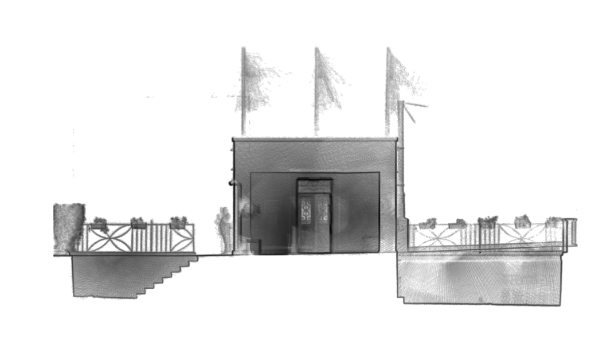
The Mount — Terrestrial LiDAR Survey
Full terrestrial scan of The Mount heritage site.
Main Street — Terrestrial LiDAR Survey
Street-level terrestrial LiDAR of Gibraltar’s Main Street commercial corridor.
Devil’s Gap — Aerial LiDAR & Photogrammetry
Combined aerial LiDAR and photogrammetry survey of the Devil’s Gap area.
Devil’s Gap — Terrestrial LiDAR Survey
Ground-based LiDAR complementing the aerial survey dataset.
Duke of Kent House — Terrestrial LiDAR & As-Built IFC
Heritage building survey with full IFC as-built model production.
Hampshire Police & Royal Gibraltar Police
Survey services delivered to law enforcement bodies in Gibraltar.
HM Government GIS — Geographical Information System
Government contract delivering structured spatial datasets for Gibraltar’s GIS infrastructure.
OS 35 — Oil Spill Monitoring
Emergency environmental monitoring of the OS 35 forced grounding using DJI Zenmuse H20N thermal and optical payload.
Survey Hardware
Professional Grade Equipment
Near-Tec Survey operates a fleet of professional survey instruments — aerial, terrestrial, and subsea — selected for accuracy, reliability, and suitability across diverse survey environments.
DJI Matrice 300 RTK
Enterprise drone platform with RTK positioning for centimetre-accurate aerial survey operations.
DJI Zenmuse L1
Integrated LiDAR and RGB sensor for high-density aerial point cloud capture with real-time 3D data.
DJI Zenmuse P1
Full-frame photogrammetry payload delivering 45MP imagery for precision aerial photogrammetric survey.
GeoSLAM ZEB Horizon
Handheld SLAM LiDAR scanner for rapid mobile capture in confined spaces, tunnels, and complex interiors.
Leica RTC 360
High-speed static terrestrial laser scanner. Available on hire for projects requiring ultra-high-density static scans.
Insta360 X5
360° camera system for colour capture and immersive virtual tour production alongside LiDAR survey data.
DJI Zenmuse H20N
Multi-sensor payload combining optical zoom, thermal, and laser ranging — deployed for the OS 35 oil spill monitoring operation.
Sonar Systems
Subsea sonar for seabed mapping and underwater observation. 3D sonar capability in development.
Survey Deliverables
Data Formats & Outputs
We deliver survey data in the formats your team needs — from raw point clouds to engineering models and immersive 360° tours.
Compressed and raw point cloud formats for GIS and engineering workflows.
CAD-ready 2D and 3D drawings for design and construction teams.
Open BIM format for integration with Revit, ArchiCAD, and other BIM platforms.
3D mesh and point cloud exchange formats for visualisation and analysis.
Georeferenced aerial imagery for mapping, planning, and GIS use.
Immersive virtual tours from Insta360 X5 imagery — ideal for heritage and client presentations.
Who We Serve
Built for Demanding Clients
Near-Tec Survey works with clients who require accurate, reliable, and professionally delivered spatial data — on time and to specification.
Government
GIS datasets, defence site surveys, infrastructure mapping, and emergency monitoring for government departments and agencies.
Engineers
As-built surveys, structural condition data, IFC models, and precise topographic data for civil and structural engineering projects.
Construction Contractors
Site progress monitoring, volumetric analysis, cut-and-fill calculations, and pre/post construction surveys.
Heritage Bodies
Millimetre-accurate heritage recording, 3D documentation, and immersive tour production for historic structures and sites.
Why Near-Tec Survey
What Sets Us Apart
Survey data is only as good as the team collecting it. Near-Tec Survey combines professional-grade hardware with experienced operators and rigorous quality control.
Proven Government Track Record
Contracted by HM Government of Gibraltar for GIS data production, and by law enforcement bodies including Hampshire Police and the Royal Gibraltar Police. Our work is trusted where accuracy matters.
Multi-Domain Capability
Aerial, terrestrial, and subsea survey from a single provider. No project handoffs between contractors — one team, one point of contact, one deliverable.
Engineering-Ready Deliverables
We don’t just hand over raw point clouds. Every project is processed and delivered in the formats your engineering, design, or planning team can use immediately.
Part of Near Technologies Group
Survey clients benefit from the group’s broader capability — drone operations under EASA and Gibraltar CAA regulation, marine survey, and IT infrastructure — enabling integrated project delivery.
Ready to scope
your survey project?
Whether you need a quote, a site visit, or a technical discussion — our survey team is ready.